Objectives of Site Investigation
The principal objectives for a highway design Site Investigation are as follows:
- Suitability: Are the site and surroundings suitable for the highway?
- Design: Obtain all the design parameters necessary for the works.
- Construction: Are there any potential ground or groundwater conditions that would affect the construction?
- Materials: Are there any materials available on-site, what quantity and quality?
- Effect of changes: How will the design affect adjacent properties and the groundwater?
- Identify Alternatives: Is this the best location?
In addition to these, it is necessary to investigate existing features such as slopes. If there is a failure of such a feature then it is necessary to investigate the failure and suggest remedial works.
Site investigation is a process of site exploration consisting of boring, sampling and testing so as to obtain geotechnical information for a safe, practical and economical geotechnical evaluation and design. Generally, it is an exploration or discovery of the ground conditions, especially on the untouched site.
In other words, the main purpose of site investigation is to determine within practical limits, the depth, thickness, extent and compositions of each subsoil stratum, the depth and type of rock, the depth and composition of groundwater, the strength, compressibility and hydraulic characteristics of soil strata required by geotechnical engineers. Sometimes it is also known as geotechnical investigation.
The Importance of SI
- To study the general suitability of the site for an engineering project.
- To enable a safe, practical and economic design to be prepared.
- To determine the possible difficulties that may be encountered by a specific construction method for any particular civil project.
- To study the suitability of construction material (soil or rock).
Why Have To Perform SI?


SI is essential for every construction project. This sketch should do the trick...
Obviously, it is a part of geotechnical processes in the preliminary stage.
Lack of geotechnical processes will lead to a:
- Failures where many case histories are available.
- Significant delay and increase in construction costs when the design has to be revised or amended.
Generally, the elimination of the site investigation will not save the cost of the project thus it only comprises from only 0.1% to 5% of the project cost. In fact, most frequent claims in civil engineering contracts are on the basis of inadequate SI or obstructions resulting in extra costs which could not reasonably have been foreseen by an experienced contractor.
Wok Procedure for SI
Steps of work involved in site investigation:
- Desk study to collect all the relevant data and information,
- Reconnaissance of site works,
- Planning program after reviewing the above,
- Ground or soil exploration includes boring, sampling and testing,
- Laboratory testing (also field if necessary),
- Preparation and documentation of SI report,
- Engineering design stages,
- Review during construction and monitoring.
Planning of SI Works
Surface Investigations:
- Site inspection to assess general site condition if there is any anticipated problems that might arise during the construction later on.
- Usually, the engineer is required to inspect the site to appreciate actual site and ground problems with particular reference to terrain, vegetation, swamps, water runoff, stratigraphical formations where it is exposed.
Sub-surface Investigations:
- Ground or soil investigation by means of boring, sampling, testing, and etc. And also as to determine the stratigraphy and pertinent properties of soil underlying the project site.
Site Reconnaissance
A reconnaissance is a preliminary examination or survey of a job site. First step is to collect and study any pertinent information already available. After collecting and studying the data available, the engineers should visit the site in person, observe thoroughly and interpret what is seen. Results of reconnaissance help to determine the scope of subsequent soil exploration. It is important to locate any underground utilities to assist in planning and carrying out subsequent subsurface exploration.
A few generalizations of reconnaissance:
- Details on the ground surface for an early observation,
- Topographical characteristics, e.g. flatland, hilly, swamps or pit area,
- The possible location of the ground water tables (GWT),
- Interviewing the local residents for further information,
- Taking a lot of photographs of the proposed site.
Steps of Soil Exploration
Soil exploration in site investigation consists of:
- Boring: Refers to drilling or advancing a hole in the ground. The test would include hand auger, motorized hand boring (wash boring), deep boring (rotary drilling), and/or trial pits.
- Sampling: Refers to removing soil from the hole. The samples can be classified as disturbed or undisturbed sampling. Disturbed samples are usually used for soil grain-size analysis, determination of liquid limit, the specific gravity of soil as well as compaction test and California bearing ratio (CBR). The undisturbed samples are collected at least every 1.5 m and if changes occur within 1.5 m intervals, additional samples should be taken.
- Testing: Refers to determining the properties from the soil. The test can be performed either at the laboratory or at the field. Laboratory testing would normally be moisture content, sieve analysis, liquid limit, compaction test, CBR and so forth. Field test would include the Standard Penetration Test (SPT), Cone Penetration Test (CPT) and Vane test.


One of SI method; Rotary wash boring...
Record of Soil Exploration
It is important to keep complete and accurate records of all data collected. Boring, sampling and testing are often costly but it is necessary in every site investigation. A good map giving specific locations of all boring should be available. All boring should be identified and its location documented by measurement to permanent features. And all pertinent data should be recorded in the field on a boring log sheet.
Soil data obtained from a series of test boring can best be presented by preparing a geologic profile:
- Arrangement of various layers of soil,
- Groundwater table,
- Existing/proposed structures,
- Soil properties data (e.g., Standard Penetration Test values).
The profile was prepared with data obtained from the boring, sampling and testing of each borehole from selected points.
Geotechnical Report Guideline
Here is the comprehensive guidelines for Site Investigation report:
- Table of Contents: Summary of content details included in the geotechnical report.
- Executive Summary: Brief to the point summary not exceeding one page of findings and design recommendations.
- Terms of Reference: Outline terms of reference and scope, identify requesting source. Find out geotechnical requirements from the project manager, structural engineer or the geometric designer at the beginning of the assignment and keep track of changing requirements thus terms of reference.
- Background Information/Review of Existing Data: Provide site description. Describe, topography and geology (in terms of engineering significance and engineering properties), seismic ground motion data, lab data, groundwater and drainage information. Provide location map, National Topographic Series 1:50,000 map reference, e.g. 92B/12, Longitude and Latitude, Universal Transverse Mercator coordinates if possible. Provide a plan profile where applicable, site history if available.
- Site Investigation: Describe what is needed in light of existing information, provide specific rationale for the scope and methods of site investigation to make it possible for reviewers to assess the adequacy of the investigation. Describe what was carried out. Show the location of test holes or pits or geophysical lines if any. Include field observations at the site, soils and existing conditions.
- Laboratory Testing: List the tests done and present the results using the standard format.
- Evaluation and Analysis: Discussion of the site investigation and laboratory test results and their implications on the proposed facility or the stability of the site investigated. The seismic assessment should be provided. Describe analyzes performed, assumptions, parameters and methods used (use two methods for analyzing slope stability or calculating bearing capacities where practical). Provide foundation or slope design information in terms of both static and dynamic (seismic) design if required and state what safety factors are in place. Provide anticipated range of settlement for foundations and fills, and Factor Of Safety of fill. Apply your field observation of the site conditions and existing foundations if any, on your choice of foundation type.
- Sand and Gravel Sources / Disposal Areas: Provide legal description, status (Crown, lease, etc.). Describe potential sand and gravel sources, tested or estimated material properties and projected quantities. Describe investigation methodology. Provide recommendations on waste or surplus material disposal areas.
- Design Recommendations, Including the Design of Pavement Structures: Point out possible foundation and construction difficulties, effects on the existing adjacent structures and suggest methods of overcoming these difficulties, recommend the preferred type of foundation, describe why and suggest possible alternatives (value engineering) where possible. Refer to findings of field investigation, lab test findings and analyzes the results. Point out that the geotechnical engineer should be given appropriate opportunity to review the geotechnical aspects of the completed design prior to construction.
- Discuss Predicted Effects of The Recommended Work on The Environment (water quality, etc.): Provide recommendations on mitigation measures. Provide specifications and special provisions for construction contract. Provide cost estimates for the recommended work.
- Literature References: Provide a list of references used in the preparation of the report.
- Appendices: Correspondence Soils and rock core logs (make sure standard disclaimers are included with the logs in contract drawings), test hole location plan, design profile for new roads, pit development plan, drawings, plan and profile, and also photos.
- Quality Control of Work: Reports must be signed and stamped both by the author and the reviewer. It is the responsibility of the author and the reviewer to determine the appropriateness and accuracy of input data and the correctness of the computed results. Use of computer programs does not free the Professional Engineer or the Professional Geoscientist from this responsibility.


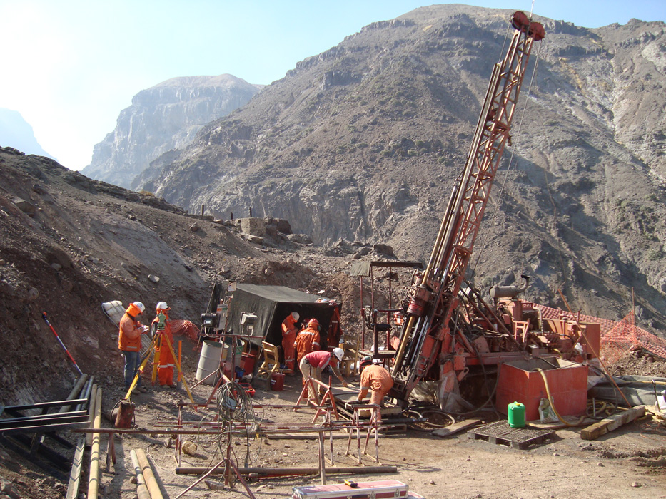
Drilling a borehole at site...
Summarizing
Scope of site investigation works when planned by different engineers tend to be varied because there are an infinite number of conditions to be met and the process of planning also leaves many areas where individual judgment and experiences must be applied. It is also impossible to attempt to provide an exhaustive step by step guidelines applicable to all possible cases. It should be realized that there is a possibility that any site investigation may leave some area unexplored or overlooked. The main risk in foundation design is the uncertainty involving in predicting soil conditions which may change with environment. The more site investigation the more it will reduce the margin of uncertainty but the time and cost requirement will be exorbitant.
Therefore the extent and the cost of site investigation should be such that risk is at an established acceptable level to the designer and also comply to the accepted code of practice.
Land Surveys and Site Investigations
If you are developing a site, from individual building plots to town centre redevelopment, or carrying out any sort of building or engineering work, you will need accurate information from the start. A survey can help you, by correctly measuring the physical dimensions of a site or building.
Furthermore, it is vital that accurate information is provided before building work starts, as it is often in the first stages of construction when mistakes can happen. It is therefore usually essential that the ground conditions and the previous history of any land are established at an early stage.
A land survey and site investigation will minimise the risks by providing data on which to base the concept, design and construction work, no matter how large or small the proposal or problem. Accurate, reliable surveys and investigations are an essential element of any successful project.
Uncertainties and risks can be reduced right from the start, because you will know the area and topography of your land or site, the limits of your boundaries, the extent of existing services, the height and position of any adjacent buildings and structures and details of sub-soil information.
A survey can also help in setting out to ensure that works are placed exactly where they are supposed to be, whether it is a simple building extension or major engineering works.
Our Engineering Design Unit can provide information on how to obtain best professional advice on many aspects of topographic, engineering and building surveys and investigations, but they are unlikely to be able to carry out any work directly for you.
Requirements for Site Investigation
In line with industry practice, the site investigation should be under the overall supervision of a Ground Specialist (ICE 1993), who should have experience of development on the waterways. The investigation should be carried out to BS 5930 (1999) standards. More information can be found from the Institution of Civil Engineers www.ice.org.uk. Soil testing must be carried out to BS 1377 (1990), by a UKAS accredited laboratory United Kingdom Accreditation Servicewww.ukas.com.
Site investigation is considered to be a construction activity and should therefore comply with the Construction, Design and Management Regulations (CDM) 2007
Please note that under the Construction Design and Management Regulations (CDM) 2007 specific legal duties are placed on organisations or individuals for whom a construction project is carried out. Please contact the Health and Safety Executive for further information:
Phone: 0845 345 0055
The Ground Model
The overriding objective of the investigation is to produce a ground model, against which predictions may be made regarding the ground response to the proposed works. The ground model requires interpretation of the geology, ground conditions including groundwater and other factors (including existing structures), by a suitably qualified person, normally a geotechnical engineer or engineering geologist.
The ground model should be described clearly using plans, cross-sections, block diagrams and other sketches as appropriate. Areas of assumption or interpolation should be clearly identified.
Ground Investigation
A detailed geotechnical survey and appraisal will be required.
Ground investigations should include the following information where the proposal connects to or interferes with the impermeable lining of an artificial cut or canalised navigation:-
- location and depth of all boreholes and trial pits
- full log of boreholes and pits including description and classification of soils and groundwater levels
- location and depth of samples
- an interpreted ground model with quantitative information on characteristics such as plasticity index, permeability (horizontal and vertical), classification by particle size distribution, angle of friction, cohesion, dry density and bulk density and dispersivity index.
- ground levels not only to Ordnance Datum but also relative to normal water level in the canal and, where appropriate, levels of flood defences, maximum flood, mean low water of spring and neap tides and mean high water of spring and neap tides
- quantitative information on contaminated land and groundwater, where applicable. We may require water quality monitoring during construction and subsequently during operation.
It is important that the level and the quality of the information provided is consistent with the complexity of the proposed works and that any subsequent design assumptions used in the temporary and permanent works are supported by the findings of such an investigation. Where insufficient Ground Investigation data is available, designers will have to use conservative soil parameters in the design of the works that may result in substantial additional costs.
The Ground Investigation should be sufficient to reduce the risks associated with unforeseen ground conditions to a tolerable level.
It should be noted that the connection to the waterway unless agreed otherwise with BW, will need to be undertaken in dry conditions. This will require the use of temporary works and/or a pre-agreed canal stoppage / partial stoppage to create a dry working area. Consideration should be given to this in the Ground investigation and in the programming and pricing of the works.
Care should be taken not to disturb wildlife when carrying out any intrusive investigations (boreholes, trial pits, etc). Of the wildlife most likely to be encountered, badgers (and their setts), nesting birds, bats, water voles and all reptiles require special attention as they are all legally protected.
No borehole shall be drilled or trial pit excavated within six metres of the water's edge or within the water channel without our written permission. Normally, this will be necessary as it is a requirement to determine the composition and properties of the bed/lining material, to assess whether the lining extends behind the bank protection, or to locate services or other buried structures, to provide the level of detail for BW to fully assess your proposals for construction of the marina entrance.
Waterway walls can be up to two hundred years old and are generally not capable of bearing loads. The plant should be lightweight only and must not load the wall or edge of the canal. A condition survey and risk assessment will be required.
Whilst undertaking site investigation works within or adjacent to the canal, appropriate measures must be taken to avoid disturbing the existing canal lining. However, if it will be necessary to affect the navigation channel, within the existing waterway width, for temporary or permanent works, then bed profiling for a sufficient distance either side of the works should be carried out. In such cases, any investigations must be agreed in detail with us in order to minimise the risk of damage to the canal.
Other conditions which must be observed are:
- Unless pre-agreed with BW, and required for safety reasons, at no time shall the waterway or towpath be blocked. Signage and suitable fencing or other barriers must be used to segregate the public from the working area. Some towpaths are public rights of way and will require Local Authority consents for closure/ diversion.
- No trial pits are to be excavated on embankment slopes below the level of the waterway or within five metres of the toe of such embankments.
- No water is to be pumped into or out of the waterway.
- No borehole or trial pit spoil or grout shall be allowed to enter the waterway and all such arisings shall be removed in compliance with waste management legislation.
- Boreholes are to be sealed and backfilled with cement-bentonite grout of an agreed specification except for any borehole within the existing waterway width. Where alternative backfilling is required (for example for a particular installation), this must be agreed with us.
- Trial pits are to be carefully backfilled and adequately compacted in layers.
- Any variations from these conditions require our agreement.
Reinstatement
All access roads used, and fences and hedges disturbed during the investigation should be fully reinstated to our satisfaction.
Where it is necessary to leave apparatus such as piezometers or survey stations on our land, the design of the installations, including details of covers etc, must be acceptable to us and a commercial agreement may also be required .
Provision of information
Relevant logs, test data and other field information must be submitted. The preferred format is paper, backed up by electronic (e.g. pdf format) copies, as well as AGS data (current version). Interpretative reports should be provided as a paper copy, together with electronic (e.g. Word or .pdf) version.
All exploratory holes must be accompanied by a 12-figure national grid reference, as well as a level to Ordnance Datum. Where it is not practical to provide levels to OD (for example where no benchmarks are present locally), then it may be acceptable to provide a relative level to an agreed datum (not water level), with a suitable witness drawing of any temporary benchmark used.
Why do Site Investigations matter?
Dredging is often described as an industry where you are working in the dark, at depths usually only accessible to fish. The dredging crew cannot see what they are doing, and neither can the client or the public. Yet the risks of encountering “unforeseen” material are not only inconvenient, but also time-consuming and invariably costly. Accurate preparation to limit as much as possible the unforeseen is the foundation for a job well done, on time and within budgeted costs.
With today’s technologies, this is a feasible goal. As much light as possible should be shed on the “ground” prior to the start of a dredging project. A well- designed site investigation informs both the contractor and the client. It reduces risks and uncertainties and enables all involved in the project to prepare properly. Site investigations are the first step toward a successful project and satisfaction on all sides and that is why they matter.
When is a Site Investigation necessary?
The simple answer is “Always”. In some dredging and maritime construction projects information will already be available and the contractor and client can depend on previous investigations. In most cases, however, thorough inspection of the entire area should be a high priority as previous investigations may not be wholly representative of the conditions which may be encountered. One of the most frequent causes of delay and additional unexpected, unbudgeted costs is an inadequate site investigation.
Since the costs of the dredging work are directly related to the risks encountered on site, site investigation is an important tool in risk management. The basic questions a site investigation should answer are:
- What types of material are present?
- Are they dredgeable?
- What type of equipment and plant will be needed?
- What will the wear and tear on plant be?
- Is the available financial budget feasible for the work to be carried out?
Who is responsible for the Site Investigation? Since the results of a site investigation directly influence the choice of plant, method of operation, and the contractual costs, it might seem that the dredging contractor should bear the responsibility of the site investigation. In reality that is not usually the case. The client is best placed to investigate the potential site given that the client is most familiar with the specific area and has the time to hire an independent site investigator, whilst the contractor has limited time to tender and usually can only summarily inspect the location before pricing the tender. For instance, a port authority seeking to implement expansion plans, will choose an independent investigative contractor to conduct the site investigation. The contractors then submit their tenders based on this third-party information. If this investigation is not actually representative of the ground conditions which are later encountered, then the question of who bears the costs of these unforeseen conditions may arise. According to the FIDIC contract, the risk of adverse ground conditions, that is, the proper cost of removing physical obstructions or conditions that are not reasonably foreseeable by an experienced contractor, lies with the client.
However, both the dredging contractor and the client must realise that in the long term that their best interests are linked and both are best served by a reliable site investigation. Reasonable estimates from the contractor based on the best possible data, plus financial relief for the contractor from the client for unforeseen predicaments will ultimately lead to more harmonious working arrangements and successful execution of the project. An investment in a top-notch site investigator can help mitigate potential conflict and unexpected surprises for both parties and go a long way to reducing the number of unforeseen events during the course of the project. The least expensive solution may look good at the start, but it is not always the least expensive at the end of the day: It does not pay to be “penny wise and pound foolish”.
What is required for a thorough Site Investigation?
The dredging and maritime construction industry has invested heavily in developing scientific means for determining the conditions of the sea- and riverbeds. This reflects an industry-wide commitment to innovation and it enables clients to take advantage of these capabilities. Generally speaking three investigative types of ground examination are recommended:
- geological and geotechnical evaluations;
- bathymetric surveys; and
- environmental assessments.
What are geotechnical and geological evaluations? Geotechnical and geological investigations help determine the type, quantities and locations of material to be dredged. Since the volumes to be dredged are used to calculate the costs of the project, the highest accuracy is of benefit to all parties. Geotechnical and geological investigations are also essential in analysing the physical and mechanical properties to determine if the sub- seabed consists of cohesive and non-cohesive soils or rock, including grain size (gravel, sand, silt or clay). Important geotechnical data include: particle size distribution, strength, plasticity, in-situ density, mineralogy, particle specific gravity, permeability, calcium carbonate content and organic content.
This information determines what type of plant is needed for construction. It may also determine the suitability for reuse of the materials, as well as whether materials with contamination will require special treatment or disposal arrangements.
Are there other sources of geological information besides field investigations?
Some information can be gathered from existing sources such as previously published geological surveys, computerised databanks, universities and research institutes, and records of previous dredging projects. Even satellite imagery and aerial photography can occasionally provide some pertinent geophysical information during planning stages. These indirect methods should support the field investigations and only be used in conjunction with other more direct investigative means on the potential site itself.
What do bathymetric surveys tell the contractor and the client?
Bathymetric surveys establish the water depths and level of the sea/riverbeds including tidal levels at a number of points. This will result in the creation of “isobath curves” or depth contours, cross sections and/or digitised grids of the investigated site. Echo sounders are the most commonly used method for assessing water depths, and today’s state-of-the-art ultrasonic echo sounders can be used in waters up to 5000 metres deep. They usually work at sound frequencies from 33 to 210 kHz which can reflect low-density fluid muds as well as the more solid layers below them. Calm seas improve the reliability of sounding data, but some movement of the survey vessel is unavoidable. This is a difficult and time-consuming process and the skill needed to achieve reliable results should not be underestimated, nor should the value of accurate data. Automated computerised systems have greatly expedited the collection of sounding data but not eliminated the need for double-checking by manual measurements.
Bathymetric surveys will also identify any operational or access restraints. However, more detailed surveys, for instance, by side-scan or magnetometer, are needed to identify obstructions such as underwater pipelines or debris.
Why are environmental assessments essential? Environmental assessments provide meteorological, hydraulic, and sediment transport information. The data may include wave action and current velocity, the degree of sedimentation, siltation and erosion, and the effects of wind, waves and weather. In the last few decades, environmental impact assessments (EIAs) have also become an essential part of site investigations. Careful study of the flora and fauna of a region such as sensitive seagrass or corals and the repercussions of disturbing these by maritime construction have become a crucial element in project planning.
What are gravity waves?
Gravity waves are divided into “sea” waves, which are located in a wave-generating area of the sea, and “swell” which occurs when the waves are no longer in the wave- generating area nor influenced by significant winds. Sea waves are steeper than swells and shorter in time length. Collecting wave data is complex and the most often recommended method is using devices that measure pressure, acoustics and acceleration, although estimations from ships as well as radar and satellites are sometimes used.
Do water levels and current velocities vary according to the type of water body? There are differences between water level fluctuations at sea, on tidal and non-tidal rivers, and in lakes and canals. Tide-generated astronomical forces that cause changes at sea are well documented and routinely predicted. Current velocity in coastal waters is influenced by the tide, wind and waves. In rivers, as well, predictions of water level are more readily available because rainfall estimates are known for longer periods and current velocity results from discharge and tidal forces. Lakes and canals require more analysis and may need closer scrutiny regarding water level, but usually they have rather low current velocities.
How are current velocities measured? Current velocities are measured by mechanical meters with horizontal axis rotor and vane; elecronmagnetic flow meters; acoustic Doppler current profilers and float- tracking or moving-boat methods. Generally speaking a reasonable overview of maximum and minimum current velocities will suffice for dredging operations.
Should weather be part of a Site Investigation? Temperatures, especially extreme heat or freezing conditions, precipitation be it rainfall or snow, and high winds and waves can influence the choice of equipment, the work method, cost and time estimates for delays, and the implementation of necessary safety measures. Severe storms such as hurricanes and tsunamis or at the other extreme, snowstorms and the formation of ice, may hinder operations. Another hindrance can be reduced visibility caused by fog. Difficult weather conditions may mean that seasonal restrictions for operations are necessary and should be incorporated into contractual agreements. This may protect the contractor from being asked to solely bear the risks of climatic conditions. Therefore, the climatic data provided must be a reasonable representation of what may be expected.
What methods are used for Site Investigations? Investigations may involve direct, physical searches – samplings – or more indirect such as geophysical means and remote sensing. Amongst direct methods are: cable-toll percussion, wash boring, rotary core drilling, vibrocoring, probing and test pits. Indirect methods include geophysical investigations and seismic reflection, refraction surveys and restivity surveys as well as remote sensing which are used more infrequently. They should not be used on their own because the data they provide is too generalised.
Direct methods yield more accurate samples that can then be laboratory tested and are thus far more useful. Keep in mind that the quality of the laboratory is extremely important for accurate and reliable test results. Ideally, laboratory testing and analyses of soil and rock samples should occur simultaneously with in-situ field investigations so that a continuous flow of information is available. In some cases, for a particularly complex situation, a trial dredging area may be advisable.
How many samples should be collected?
Enough samples should be collected to ensure that the site to be dredged is adequately covered and that it accurately reflects the composition of the ground. Although because of the variety of factors, there is no standard plan, the collection of field samples should be carefully planned including mapping, statistical designs, types of gear and techniques to be used, and the estimated scheduling and costs. The more samples are taken, the higher the costs will be, but, on the other hand, the client should feel confident with the degree of information acquired. There are objective systems for determining how many samples should be enough.
Are there other aspects to a Site Investigation? Broader “above water” types of investigation should also be mentioned. Knowledge of the frequency of marine traffic, obstructions such as debris, the location of out- falls, navigational markers or buoys, regulations specific to the particular harbour, as well as applicable national, international and local laws, and support and safety facilities such as air-sea rescue services, tugs, safe havens, and fuel and electricity supplies are also part of “investigating” the site.
Other pre-dredging investigations could be evaluation of noise and air quality, the presence of cultural or archaeological objects of value, and the impact of dredging on area activities, for instance, recreation. The more knowledge the contractor, client and for that matter the public, has the better chances of a cost-effective operation in which risks are minimised and the likelihood for satisfaction are enhanced.
How does a client find a reliable investigative contractor?
Experience and qualifications count. The investigative contractors should be properly qualified by the appropriate governmental authorities and be working in accordance with national standards and/or codes, as well as knowledge of the requirements of dredging and maritime construction contractors. The data assembled by the investigative team of engineers and geologists must be clear and fulfill the needs of these potential dredging tenderers. To achieve this, communication channels between the designers of the project and the investigators must be established early on and maintained throughout the investigation, allowing for adjustments as data becomes available. Reliable data is the basis for a smooth operation.
What are the risks if a Site Investigation is not thorough?
The costs of sub-sea site investigations are not insignificant and so the temptation to take short cuts or limit the investigations can be great, but in the long term this is unwise. Soil investigations on land are more accessible and readily implemented and thus less costly, which makes underwater investigations appear expensive by comparison. Unjustly so. Underwater investigations are more complicated and time-consuming. What may seem expensive or even extravagant upfront may reduce risks and prevent far greater additional costs as the job proceeds. Ultimately you get what you pay for.
Unfortunately, too often insufficient time is allocated to perform an adequate site investigation and “short cuts” are taken. A better solution is to provide an extension of the tender date in order to allow for the collection of all available data.
What are the advantages of a reliable Site Investigation?
At a project site that is thoroughly and reliably investigated, the “dredgeability” of the site will be clear. The type of material – rock, sand, clay or stone – will be known, whether it is homogenous or not, the hardness, thickness, depth and number of layers. This will help determine the proper excavation methods, as well as the methods for transporting the excavated material, through pipelines or by hoppers or barges. It will also help determine the final use, re-use or disposal possibilities of the dredged material. The element of unpleasant surprise will be reduced, and so will the risk factors. And reduced risk factors result in more accurate cost estimates, which in turn result in less disappointment and more satisfaction, a “win-win” result for both client and contractor.
Planning A Site Investigation
"The main investigation is the full investigation of the site using boreholes and trial pits and includes the preparation of the site-investigation report with revised plans and sections, interpretation and recommendations for design."
They consider that there are two aspects to the site investigation. The geological structure and character of the site and the testing of the soil both in the laboratory and in-situ. They suggest that planning should consider the following questions.
- Is the succession of strata known over the whole site and is there correlation across the whole site known? What measurements of depth dip and outcrop are required to clarify the stratigraphy? Should any key measurements, such as depth to bedrock or peat, be made?
- Are the different strata fairly homogeneous over the site or do local variations exist? Are there more complex areas of strata that require investigation or closer examination during construction? Will there be areas where the excavated material will be unsuitable for fill and will need to be replaced? Are there areas where needs to be assessed to ascertain working methods?
- Are there ground structures that need closer examination - for example, the extent of disturbed strata, the location and extent of natural cavities and mine workings, their liability to cause subsidence or movement, the extent and depth of surface movement and instability? Are there other phenomena likely to give rise to instability such as fractures and river crossings or alluvial areas that may have buried soft material or peat? Are there likely to be any undetected structures?
- Will any part of the route be subject to flooding? What contact will there be with water-bearing strata and will groundwater lowering methods be required during construction?
- Do requirements for the carrying out of special in-situ tests or the taking of undisturbed samples affect the conduct of the qualitative investigation? For example, with forethought, a single trial pit may be made to serve both for examining ground materials and structure, and for the in-situ testing and the taking of block samples.
Dumbleton and West state that these questions should be asked for the whole route and must be related to the proposed geometry of the road and it's structure. Investigations must be carried out to the depth at which ground conditions cease to affect the work. The more complex the situation, the more extensive the investigation will need to be.
The investigation must then be planned to answer the above questions and associated problems. As much information should be obtained from the points examined as each point is expensive. These are frequently used to clarify the interpretation of the site as a whole. Bridge sites, high embankments and deep cuttings are all points of engineering complexity and should be examined thoroughly.
Ground Investigation
Ground investigation is taken to be that other than the information available from the walk over survey as discussed previously.
There are two principal methods of investigating the ground conditions, trial pits and boreholes. In addition, the reader should be aware of geophysical techniques such as seismic surveys, which are not discussed here.
Trial Pits
Trial pits are shallow excavations going down to a depth no greater 6m. The trial pit as such is used extensively at the surface for block sampling and detection of services prior to borehole excavation.
| Depth | Excavation Method | |
| 0-2m | By Hand | |
| 2-4m | Wheeled Back Hoe | |
| 4-6m | Hydraulic Excavator |
An important safety point to note is that ALL pits below a depth of 1.2m must be supported. In addition care should be taken as gases such as methane and carbon dioxide can build up in a trial pit. Breathing apparatus must therefore be used if no gas detection equipment is available.
Support for a trial pit generally takes one of three forms:
- Timbering
- Steel frames with hydraulic jacks
- Battered or tapered sides
Three types of sample can be taken from a trial pit:
- Disturbed Sample - Samples where the soils in-situ properties are not retained.
- Block Sample - A sample that is not undisturbed but retains some in-situ properies.
- Push in tube sample - Tube samples of the soil in a trial pit.
When preparing a trial pit log, the following information should be included. The location, orientation and size of the pit; sketches of faces; depth scale; root structur; water level; seepage. In addidtion the weather at the time of sampling should be noted as many soils are weather dependant.
It is extremely important when finished to reinstate the trial pit as well as possible.
Boreholes
A borehole is used to determine the nature of the ground (usually below 6m depth) in a qualitative manner and then recover undisturbed samples for quantitative examination. Where this is not possible, for in gravelly soils below the water table, in-situ testing methods are used.
Obviously, the information gained from a borehole is an extremely limited picture of the subsurface structure. It is therefore essential to compare the results obtained with those that could have been expected from the desk study. The greater the number of boreholes the more certain it is possible to be of the correlation and thus to trust in the results.
The two principal types of boring machine used for Site Investigation in the United Kingdom are light percussive and drilling machines.
Light Percussive is the process of making boreholes by striking the soil then removing it and the most common method is the shell and auger. This is a general term to describe various tools suspended from a triangular tripod incorporating a power winch. The tools are repeatedly dropped down the borehole while suspended by wire from the power winch.
The different tools used include:
- Clay Cutter - Used in cohesive materials and is raised and lowered, using it's own weight to cut into the material.
- Shell - Used for boring in silts and sands. Similar to the clay cutter, but has a trap door at the bottom to catch material.
- Chisel - Used for breaking up hard material such as boulders or rocks. Additional payment is required for chiselling as per the Bill of Quantities and permission is normally required from the Resident Engineer before work can start.
Drilling is the process of boring normally by using a combination of a rotating action and a hydraulic ram. There are many different types of rig depending on access and type of ground expected. Hollow drilling rods enable a flush of water, air, foam or mud which is used to carry the cuttings to the surface as well as lubricating and cooling the drill bit. The three main types of drill bit are:
- The double tube is where the outer tube rotates and allows for the removal of the cuttings while the inner tube is stationary and prevents the core from shearing. There are different designs of tube varying the location of the flush discharge so as to prevent sample erosion. It is necessary for the hole to be bigger than the tube and so the diamond bits are attached to the outside of the hole, thus allowing the flush to return to the surface.
- Triple tube incorporates a third tube to protect the core even further during extrusion and can have either a split tube, which is removed or a plastic tube to provide long term protection. A less effective alternative is to incorporate a nylon liner in a double tube.
- The retractable triple tube is a variation where the inner tube is attached to a retractor and can extend beyond the cutting edge. This gives complete protection to the core in softer rock whilst in harder rock where this is not necesary, it retracts to become a standard triple tube. This is used in alternating soft/hard rock, typical of a weathered profile.
No comments:
Post a Comment